Loch Levens Lakes Trail: Norden, CA

LENGTH: 7 miles round-trip. Total hiking time = 4-5 hours, not counting lunch/snacks breaks.

DIFFICULTY: Moderate-difficult, with serious hill-climbing and boulder-scrambling – worth it.

DIST FROM SACRAMENTO: 1 hour & 15 mins, via I-80 BUS E.

DIST FROM GRASS VALLEY: 45 mins, via 20E & I-80E.

537 (3) 533 (3)

LOCATION: Just plug in “Loch Leven Lakes Trailhead” – you’ll get the Tahoe National Forest result in your Google Maps and you’re on your way.

Okay, first thing. Don’t skimp on wearing your hiking boots for this one. Your ankles will be oh so grateful. That said – it’s always fun to be a mountain goat for a bit, right? Biggest tip I can offer for this one, since the trail’s a bit stop & go for the first few miles (is that it? oh, maybe not…) watch for the cairns along the way. They’re fairly easy to spot if you’re looking (see below for the world’s tallest, near the Upper Lake) and a big help if you need a quick compass arrow to guide you.

When things start getting steep about 1/4 mile in, look for a large boulder up on your right. If you continue jogging right you’ll hit the pine trees and a small campsite. You can pick up the trail there, and will soon wind around a boulder with a small pond on the left. It’s easy going after that. If you miss it…no stress, you can pick the trail up again at a later point!

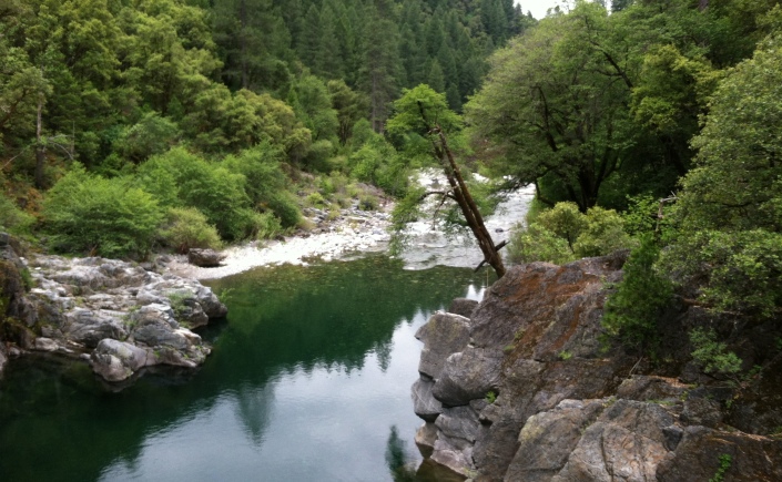
You’ll cross a small 536 (3)
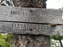
bridge after 1.5 miles or so, then the railroad tracks. You reach the Lower Loch Levens Lake after 2.5 miles (and an option to travel to Salmon Lake). The Middle Lake is another 1/4 mile, then it’s under a mile to the Upper Lake (3.5 miles in then). You can fish at the lakes, or camp overnight – quite a few good spots, but I’d recommend heading in early on a busy summer weekend.

You’ll end up at 6500 feet at the highest point! This is definitely snow-country, and looks like snowshoers have trekked it before according to the Internet…could be fun.

FUN FACT: The railroad tracks you’ll cross a few miles in were originally built in the 1860’s, as one of the first transcontinental railroad lines from Omaha to Sacramento. AKA “a modern engineering marvel of its time” – love all the great history we have around this area!

THUMBS UP: One of the best hikes I’ve seen around here where you can easily hit 3 beautiful lakes in a day trip. Fairly shady, with cool breezes from the water. Gorgeous views if you feel like scrambling up the boulders around the 2nd/3rd lakes. Picnic spot heaven. Not too buggy. Bathroom at start.

THUMBS DOWN: It wasn’t that busy when I went, but I imagine the trail could get pretty crowded.

535 (3) 552 (3)

Euchre Bar Trail: Alta, CA

Okay, before we even dive into this one let’s start with a disclaimer…
Don’t worry, there are some pretty awesome perks too…

Youre ready for this hike if you

1) Have dreams of someday hiking [insert challenging, classic endurance hike: PCT, High Sierra…]
2) Have excellent tread on your shoes
3) Carry highly-effective bug-spray as a staple (let’s just say I had motivation to get back up FAST)
4) Have knees in great working order
5) Have absolutely no plans requiring you to look remotely acceptable in public post-hike

If so, then you can look forward to

1) The smell of fall leaves, even during the heat of summer
2) A gorgeous green 1950’s bridge over the water at the canyon bottom
3) Rolling, green, panoramic mountains for miles — more like Washington than California really
4) A pretty quiet, un-peopled hike
5) Even better, a lot of great not-people interactions (fox, fish, birds galore)

LENGTH: 
8 miles round-trip, if you do it all/have calves of steel/passed the litmus test above with flying colors. Even if you just do the down and up 4 mile stretch, that’s pretty back-pat worthy.

DIFFICULTY: No sugar-coating. Difficult is the right rating here. 1600 feet elevation loss, then gain!

DIST FROM SACRAMENTO: 1 hour, 15 minutes, via I 80E.

DIST FROM GRASS VALLEY: 45 minutes, via CA 174/I 80E.

707 (3)736 (2)

LOCATION: 36180 Casa Loma Rd, Alta, CA 95701 – in the Tahoe National Forest. {Can be Google mapped, BUT I highly suggest writing directions down the old fashioned way too…service was spotty for me, and you don’t want to forget which was to go after the 2nd set of double train tracks|. Also, highly suggested to park at the first (upper) parking lot by, or above the bathrooms. I wouldn’t recommend driving that rocky road, even for a 4-wheel drive vehicle.

That being said, once you’re parked you’re715 (3) 
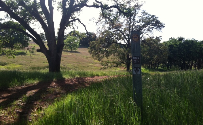
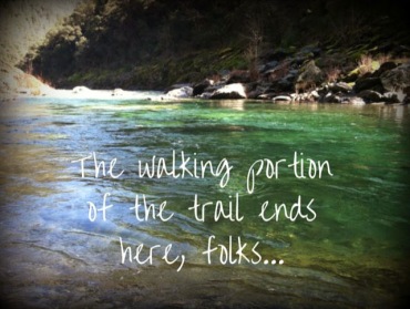
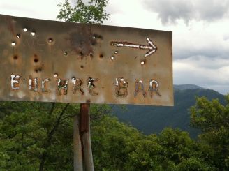
good to go. As long as you’re alert enough to spot the one “Euchre Bar —arrow” sign on the right (which yes, I somehow missed as being a general, rather than a specific take-this-trail-down-the-canyon-now guidepost) you’ll be good to go. Yep, it’s 2 miles pretty much straight down, with some zig-zagging switchbacks along the way. Lots of ferns, glimpses of the river canyon and a pretty peaceful descent overall.

I will say…the extra mile-or-so trek I took down past the turn-off sign I missed did have even more open views though. So if you’re the kind of admirable person who likes doing an extra steep up&down warm up, knock yourself out and it may just be worth it.

Once you get down the water, things get so beautiful. This rusty green 1950’s bridge with wooden slats stretches across the North Fork of the American River, and I haven’t seen a more perfect picnic/yoga spot in awhile. Glance over either side and there are great swimming pools (even a rope swing already tied around a limb) and, if you’re still not tired yet – you can climb up along the river for another 2 miles. (Great views I hear, another day…)

FUN FACT: (More of a laugh). When you type this trail into Google you may get Euchre Bar Massacre as a result…don’t worry, it’s not the stage of some cowboys&gold kings kind of event. Apparently a 50 mile run somebody thought to call a massacre (hmm…deadly?) occurred here in 2013.

THUMBS UP: Spectacular rolling mountain views, dense forests, less-busy than many hikes, great swimming holes, new muscles the next morning…

THUMBS DOWN: The hike back up is pretty brutal, the bugs are awful and extra bloodthirsty (bug-spray, check?). Otherwise, this is one of my favorites I’ve hiked yet.

735 (2) 755 (2)

Olmstead Hill Loop: Cool, CA

LENGTH: 9 mile loop for the main trail. Lots of side trails (both well-marked and not), if you’re feeling adventurous. As with the best trails around this area, you can get down to the water (fork of the American River) to cool off.

DIFFICULTY: Gentle overall (about 400 ft elevation gain), except if you take the gravel road down to the river, the hike back up is pretty unforgiving – steepness and shade-wise. But hey, with wet feet on the way back…totally worth it.

DIST FROM SACRAMENTO: 45 minutes, via I-80 E.

DIST FROM GRASS VALLEY: 45 minutes, via 49 S.

LOCATION: You can Google Map “Olmstead Loop Trail Trailhead, 7200 Saint Florian Court, Cool, CA” and it’ll lead you right to it. You’ll park behind the fire station in a well-marked lot. NOTE: $10 to park there, since it’s in the Auburn State Recreation area. The trail markers are pretty regular along the length of the trail (1/2 mile intervals and general guideposts) which is nice, as long as you’re on the main loop. But if you’re anything like me and choose the skinny less-traveled looking offshoots it shouldn’t be too hard to find your way back to a labeled trail intersection either.

The descriptions I read before I went talked about horse and mountain bike traffic, but the weekend I went I didn’t meet horses or bikes, just hikers. And the wildflowers – wow – some of the more beautiful ones I’ve seen anywhere, and that includes the legendary Buttermilk Bend Trail. I had to look a few up when I got home. On the left is the Coast Iris (which yes…you’d think would be along the coast, it sure looks like one though – endangered too) and White Globe Lily (native to CA).

Keep your eyes open, I saw more wildlife on this trail than I have on any other hike around here yet. Foxes to quail to river ducks…and more in-between.

Fun Fact: Olmstead Loop was named for Dan Olmstead in 1993. “Olmstead was an local avid mountain biker and hiker. He dedicated himself to creating harmony between hikers, mountain bikers and equestrians, and to multi-use of trails in this area. He also established a bike and hiking shop in the area.” Sounds trail-name worthy, huh?

611 (4)   613 (3)

THUMBS UP: Well marked, lots of grand oak trees, wildflowers when in season.

THUMBS DOWN: Paying to park, there are a couple confusing forks that’ll lead you onto private land if you’re not careful, pretty rocky (not really a downside, just be aware you may want hiking shoes, not tennis shoes).

625 (3)616 (4)607 (4)

Rice’s Crossing Yuba Rim Trail: Yuba County

LENGTH: 2.25 miles each way, so 4.5 total round-trip.

DIFFICULTY: A mix of flat stretches and switchbacks, I’d say less than 1000 feet elevation gain overall. When I walked the trail there were a number of people in their 60/70’s chugging along just fine. That being said…the trail’s still unfinished so there were blackberry brambles, limb ducking and some miscellaneous scrambling involved. Probably not ideal for little kids or new shoes.

DIST FROM SACRAMENTO: 1.5 hours, via CA 70 S/I-5 S and 20W.

DIST FROM GRASS VALLEY: 45 mins, via CA 49 N and Marysville Road.

LOCATION: Between the towns of Dobbins and Camptonville. You can’t Google Map this one unfortunately since it’s brand-new (exciting right? it’s an adventure…) so I’ll give you the directions that got me there: Take Hwy 49 N past all the Nevada City exits and take signs for Downieville on your left. Continue winding up 49 N for about 20 miles – past Independence Trail, through North San Juan – until you see Marysville Road. Make a left there and continue until Bullards Bar Dam; cross that monolith and about 2 miles after you’ll see a parking lot on your right with Bear Yuba Land Trust signs. Park in the lot and cross the road to the meadow to find the trail.

Okay…now to the details. This will be a beautiful and well-maintained trail, I have no doubts about that – between Bear Yuba Staff, CCC, Americorps, trail volunteers and who knows who else putting their sweat and backhoes into building this hike – it’s an amazing addition to walks already paralleling the Yuba River watershed. That being said, I would only recommend hiking this one tomorrow if you’re adventure ready. Maybe you’re a trail blazer and are poison oak immune and shouldn’t listen to me…you know your hiking mojo. The view point at the top still needs some clearing (my name pick was peek-a-boo point) and the final stretch requires a little guiding to be sure you’re still on the path. But they were flagging the trail literally as we walked, so updates in the works!

626 (4)629 (3)

Bear Yuba Land Trust is really an incredible group – if you don’t know their story and the work they’ve done be sure to hike Hirschman’s Pond Trail, Deer Creek Tribute Trail and Alan Thiesen Trail (just to pick a few). We’re lucky to have them in our community. This trail unveiling was in conjunction with their 25th birthday (yes, folks, there WAS CAKE) but in all seriousness, being there for the opening trek was pretty special. A member of the Nisenan Tribe helped put the land in historical context, which in itself was such an important thing.

THUMBS UP: When the Yuba’s really flowing well (which I’m trying so desperately to picture) and the trees are trimmed a bit, there should be an incredible view. The walk’s pretty gentle overall, and shady for good stretches – great for a hot summer day.

THUMBS DOWN: A little off the beaten path, unless you’re hanging out an Bullard’s Bar Dam/campground. I know this year’s especially bad so maybe not the best standard…but poison oak minefield, goodness. Don’t forget the bug spray too!

633 (2)636 (3)638 (3)

Buttermilk Bend Trail: Penn Valley

LENGTH: Under 2 miles, out and back. A couple other loops optional.

DIFFICULTY: Very easy, gentle winding trail along the Yuba. If you want to get your cardio in though, there are a few offshoot trails that are steeper along the way. A couple miles in there’s a straight up path, switchback style, that leads back up to the Hwy, right past a gate. Beautiful sweeping view from the top if you go the extra distance.

DIST FROM SACRAMENTO: 1 hour & 15 minutes, via 70N and 20E.

DIST FROM GRASS VALLEY: About 20 minutes, follow 20W towards Marysville/Penn Valley.

LOCATION: South Yuba River State Park at Bridgeport (Visitor’s Center where paid parking is for the trail): 17660 Pleasant Valley Road Penn Valley, CA 95946.

The highlight (minus the Yuba’s glory) is definitely the wildflowers during peak-bloom time. Which, this year, happens to have begun in mid-February – wild. There are dozens of flower markers along the trail. If you want a proper tour, there are docent-lead walks on weekends.

You can read about the most common wildflowers found along the trail here. Or, if you’re a total plant nerd (as I’m becoming) you can find the whole Nevada County wildflower list on Calflora Plant Search – almost 2000 annual/perennial flowers listed just for this county! The wild hyacinth (below, purple), pretty face (below, yellow – the sweetest flower name ever?) were everywhere.

Dichelostemma capitatumTriteleia ixioides

Once you hit the end of the trail (the last portion had a closed sign blocking it when I walked there last, so finished by winding down to the water) you can easily scramble over the boulders to get to a beach. Leave a cairn behind 🙂

THUMBS UP: Flat trail, easy way to access the Yuba (swimming holes galore), wildflower heaven, great picnic spots, amazing river views.

THUMBS DOWN: Can get crowded on the weekends, especially when there are groups stopping at each flower marker. Need to pay to park in the lot (but not much).

783764

Stevens Trail: Colfax

LENGTH: 4.5 miles each way, out and back (with, of course, some extra time necessary for playing around in the water), can camp out on the beach too if you want a whole river weekend.

DIFFICULTY: Drops 1000 feet in elevation down the canyon. Some boulder scrambling required, a few steep stretches – nothing too technical, but not ideal for running, horses or…if you have a fear of heights. Mostly flat, a little rocky – breathtaking.

DIST FROM SACRAMENTO: About 1 hour, via I-80 E

DIST FROM GRASS VALLEY: Under 30 minutes, following CA 174E to Colfax

LOCATION: 24960 N Canyon Way, Colfax, CA 95713 (Google Maps has got this one down, luckily). The one-lane dirt road I took there from my house made it seem a much more secluded spot than it actually is…since it’s BLM managed the trailhead is well marked.

Hike Fun Fact: Though it’s an old road, apparently this trail was unused in recently history until the 1960’s, when a Boy Scout re-discovered it. Good they’ve got keeping in shape in their motto, huh?Plus…it’s on the National Register of Historic Places – no idea that was possible for a hike!

I’m going to call this hike our N. California version of the Grand Canyon rim trail. Granted, I’ve only seen the Grand Canyon from pictures but this felt extremely grand. Winding around corners where you don’t know what Mediterranean-blue part of the American River you’ll see spilling in big folds towards you next…it’s pure poetry, absolutely.

The trail’s well marked, only a few portions that requires a “go this way” sign. It’s not a hike for when you want some quiet time – the parking lot seems to be regularly filled to capacity judging by the rows of cars parked along the sides of the road up to the trailhead. Still, even with the probably hundreds of people you may pass, that roar of the river below you cancels out the times you’re stuck behind an older couple with their walking sticks plodding along.

Stevens Trail

Keep your zen going, it’s worth heading all the way down to the final stretch of the river. The trail ends 4.5 miles in at a rocky beach on the river, where a make-shift camping/fly-fishing/swimming/grilling site was in full swing. Of course once the trail ends, it’s time to get wet!

On a hot summer day (or, a March like this one jeez) I’d recommend a big water bottle and another waiting for you in the car too, you’ll be glad you brought it. SO MANY GOOD PICNIC SPOTS. It’ll be hard to choose.

THUMBS UP: Views, views at every turn, with a couple 180 degree stretches where you can see both up/downstream for miles. There’s a waterfall a few miles in, too. Pretty gentle elevation. Well marked.

THUMBS DOWN: Busy, plan to park down the road if you get there after noon on a weekend. Not a lot of shade once you’re on the rim portion. There really isn’t much to knock off about this one!

Stevens Trail (1)

Foresthill Divide Trail: Auburn

LENGTH: <11 miles (most guides give a range, but with added loops there’s even more trail)

DIFFICULTY: low-to-moderate, some hill climbs

DIST FROM SACRAMENTO: 45 mins, via 80E

DIST FROM GRASS VALLEY: 35 mins, via CA 49S

LOCATION: Right outside of Auburn = 15800 Foresthill Rd, Foresthill, CA 95631 (use this, NOT Google Maps’ location for “Foresthill Divide Trailhead”) BONUS: you cross over the tallest bridge in California!

NOTE: You have to pay $10 to park at the trailhead…so be sure you’ve got cash/check on you. I can tell you now…they patrol frequently and no finger crossing will spare you the ticket!!

Foresthill Divide is a single-track trail. For those of you still learning biking lingo, it’s slated for mountain bikes first and foremost, which is good to keep in mind. I wasn’t the only hiker when I went, but I could count on both hands the number of people I passed who weren’t on two wheels.

As long as you don’t mind stepping off the trail now and then, you’ll be fine. All the bikers I met were courteous and careful for my safety…to the point where my new name became “HIKER!!!” We played a strange game of tag where I’d catch up to a group of bikers resting for a minute, they’d see me and take off to avoid passing me again – hiker power, eh?

The trail is a loop, and if you’re feeling up for the long haul you can end up right back where you car started. I was more into exploring this first time around, so I started at the East parking lot (Grizzly Bear House Turnout, where the location above will get you to) and made it to the Rock-a-Chucky Trailhead and back. Rock-a-Chucky is on the map above Drivers Flat Road (and where there are bathrooms FYI). Between that stretch you’ll spot the American River, panoramic vistas rising above the dusty red trail and helpful mile markers to guide you along the path.

THUMBS UP: Shady for the most part, nicely marked trail, gentle hills, can get to the river if you want to swim.

THUMBS DOWN: Bike-traffic heavy and unshaded for the first few miles (brutal heat in January, so summer would probably call for double-fisting water bottles), paying $10 to park at the trailhead.
Fullscreen capture 252015 72247 AM.bmp

map

map 2

Welcome

Hi there!

Welcome. Are you new to California too? Or maybe you’re just needing to get outside for awhile, get over a long week or clear your head. It’s a pretty beautiful thing how a few miles on a trail can do that. I just moved here a few months ago from a land of far less sun (also of Glacier Park, large moose and 3 foot snowdrifts) so hikes in January is big news to me. I’m learning my landscape hike by hike, which I’ll write about here, and I’d love to hear what new trails you discover too. Boots up!

Jenny